

REMEDIATION AND RECOVERY
LEGACY SITES UNDER LICENSE.
DISA Uranium holds NRC Source Materials License No. SUA-1605, the first and only license authorizing the remediation and recovery of Abandoned Uranium Mine (AUM) waste across multiple sites. Paired with remediation-and-recovery agreements with mine owners across the West, the license gives DISA Uranium a pipeline of legacy sites where cleanup and uranium recovery happen in the same step — and where the recovered uranium, at the majority of sites, is DISA Uranium’s to deliver into the domestic fuel cycle. Feedstock with no new ground disturbance.
CONVENTIONAL PRODUCTION
PAST-PRODUCING. READY GROUND. BUILT FOR HPSA TECHNOLOGY.
DISA Uranium’s conventional base is anchored in the Colorado Plateau of southern Utah — the historic heart of American uranium production. Each mine in the portfolio is a past-producing underground operation with underground development and a production history already in place. And each holds tabular sandstone-hosted mineralization of the kind HPSA technology is designed to concentrate: upgrading feed before it moves, cutting the tonnage hauled and milled, and shrinking the footprint of production.
That is not a theory. Test work on Tony M ore concentrated uranium-bearing material into roughly 25% of its original mass using HPSA technology, with beneficiation testing demonstrating greater than 90% uranium recovery. More uranium, from the same resource base, with less moved to get it.

THE CORNERSTONE.
TONY M MINE
Location
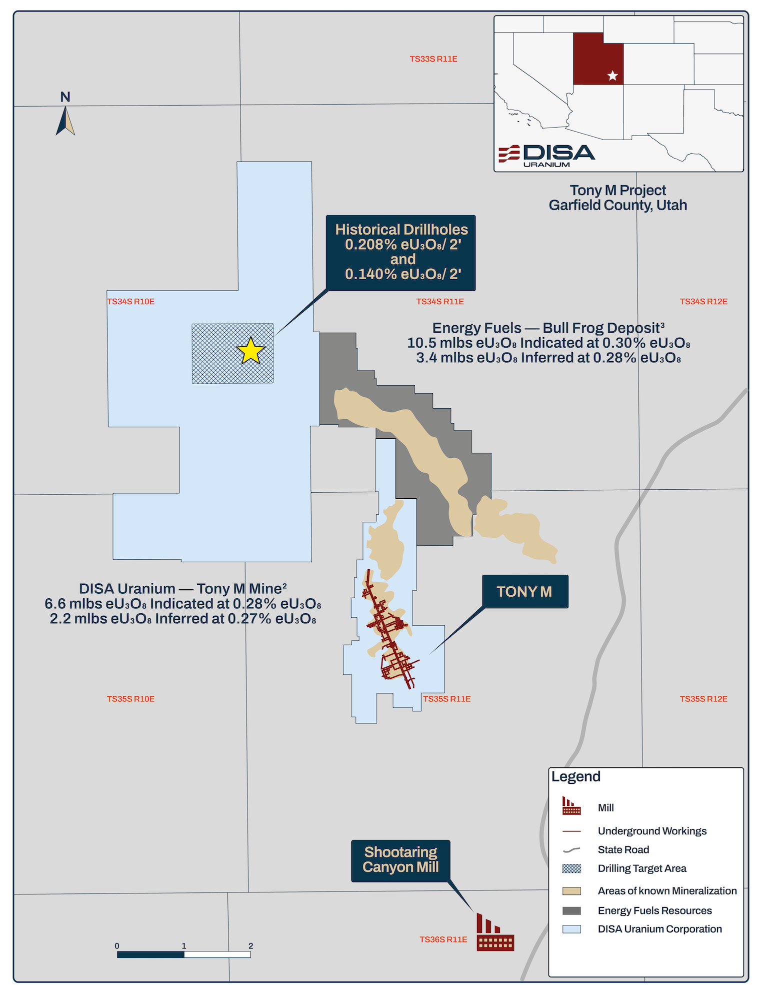
Henry Mountains uranium district, Garfield County, Utah — five miles north of Ticaboo
Deposit
Tabular sandstone-hosted uranium (Salt Wash Member, Morrison Formation), with associated vanadium
Stage
Past-producing, fully developed and permitted underground mine; rehabilitated 2024–2026
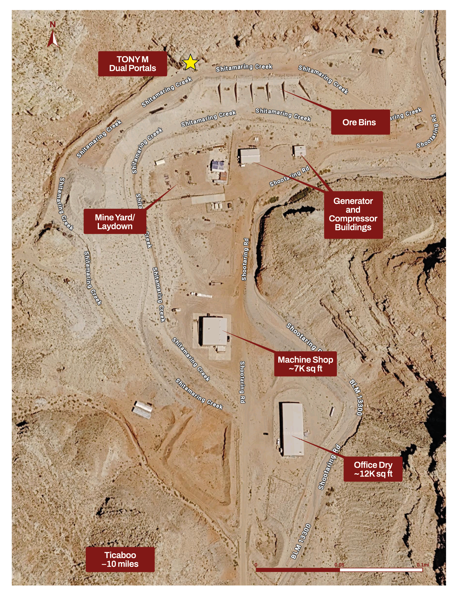
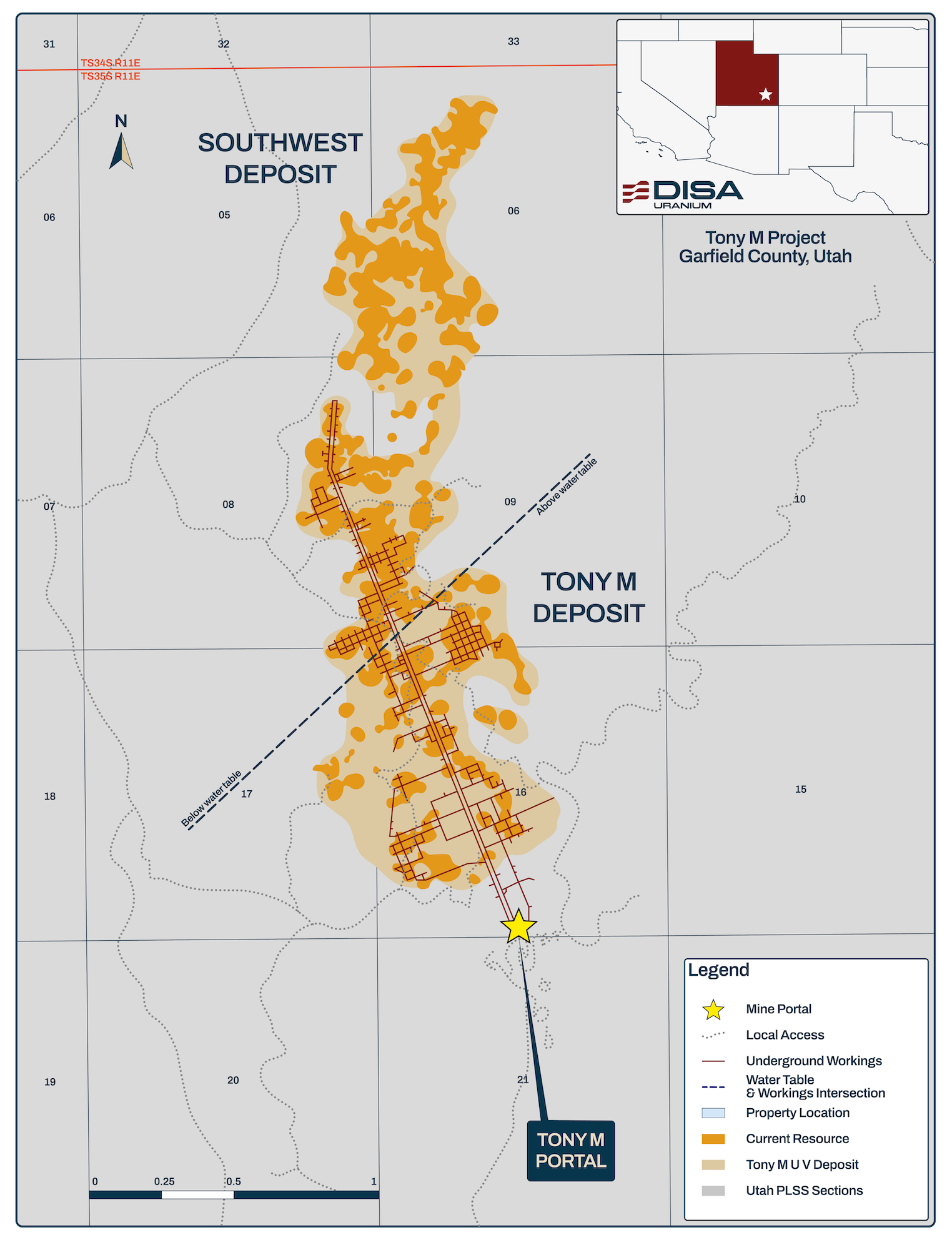
Tony M is a large-scale underground mine with 18 miles of existing underground development, two parallel declines, and surface facilities that need little refurbishment to return to production — power generation, ore bays, a 7,000-square-foot machine shop, a 12,000-square-foot office and dry, fuel storage, and an evaporation pond. Originally developed by Plateau Resources in the late 1970s and most recently operated by Denison Mines in 2007–2008, the mine has been maintained in a ready state with all required permits in place to resume operations.
Between 2022 and 2026, the mine was systematically de-risked: confirmation and infill drilling verified historical results and upgraded the resource; the main decline was reopened in July 2024; underground rehabilitation, ground control, ventilation upgrades, and a LiDAR survey followed; and in 2026 a bulk sample of approximately 2,100 tons of mineralized material validated mining methods and operating procedures while supplying representative feed for processing studies and restart planning.
- Two parallel declines extending 10,200 feet and 18 miles of existing underground development.
- Historical production of approximately 885,000 pounds U₃O₈ (1979–1984 and 2007–2008).
- Main decline reopened July 2024; rehabilitation, mapping, and LiDAR survey complete.
- 2026 bulk sample program: approximately 2,100 tons of mineralized material extracted.
- Ongoing technical studies defining production parameters, operating costs, and capital requirements.
- Vanadium upside: 2022 drilling returned V₂O₅:U₃O₈ ratios averaging 1:1 and ranging above 17:1 within the mine area.
Historical Mineral Resource Estimate
Category
Tons (000s)
Grade (% U₃O₈)
Contained (M lbs U₃O₈)
Indicated
1.1
0.28
6.6
Inferred
0.4
0.27
2.2
Notes: Canadian Institute of Mining, Metallurgy and Petroleum (CIM)(2014) definitions followed for all mineral resource classifications. Mineral resources estimated at a cut-off grade of 0.14% eU₃O₈, calculated using a US$65/pound uranium price. Past production (1979–2008) removed from the mineral resource. Estimated mill recovery 96%. Totals may not add due to rounding. For additional information, refer to the Technical Report entitled “Technical Report on the Tony M Mine, Utah, USA – Report for NI 43-101” with an effective date of September 9, 2022, prepared by SLR Consulting (Canada) Ltd. The qualified person for the report is Mark B. Mathisen, C.P.G., Principal Geologist, SLR Consulting International Corp.
Historical Production
Operator
Period
Tons Produced
Average Grade (% U₃O₈)
Contained (lbs U₃O₈)
Plateau
Sept. 1979 – April 1984
237,000
0.121
574,500
Denison
Sept. 2007 – Dec. 2008
94,100
0.165
310,500
Total
331,100
0.134
885,000
Note: Denison figures include 72,359 short tons at 0.091% eU₃O₈ (131,647 lb eU₃O₈) from stockpiled material shipped to a regional mill in 2007–2008.
Exploration
The property also hosts the Southwest deposit adjacent to the Tony M workings, and the Flatiron Project approximately seven miles to the northwest. Flatiron follows up on regional exploration from the early 1980s and tests high-priority Salt Wash targets along trend with known mineralized systems: an initial campaign of approximately 15,000 feet of drilling in 2025, followed by approximately 11,000 feet of planned drilling in 2026 to refine the geological model across the Henry Mountains district.
READY GROUND IN WHITE CANYON.
DANEROS MINE
Location
White Canyon mining district, San Juan County, Utah
Deposit
Tabular sandstone-hosted uranium (Shinarump Member, Chinle Formation)
Stage
Past-producing, fully developed and permitted underground mine; on standby since 2012
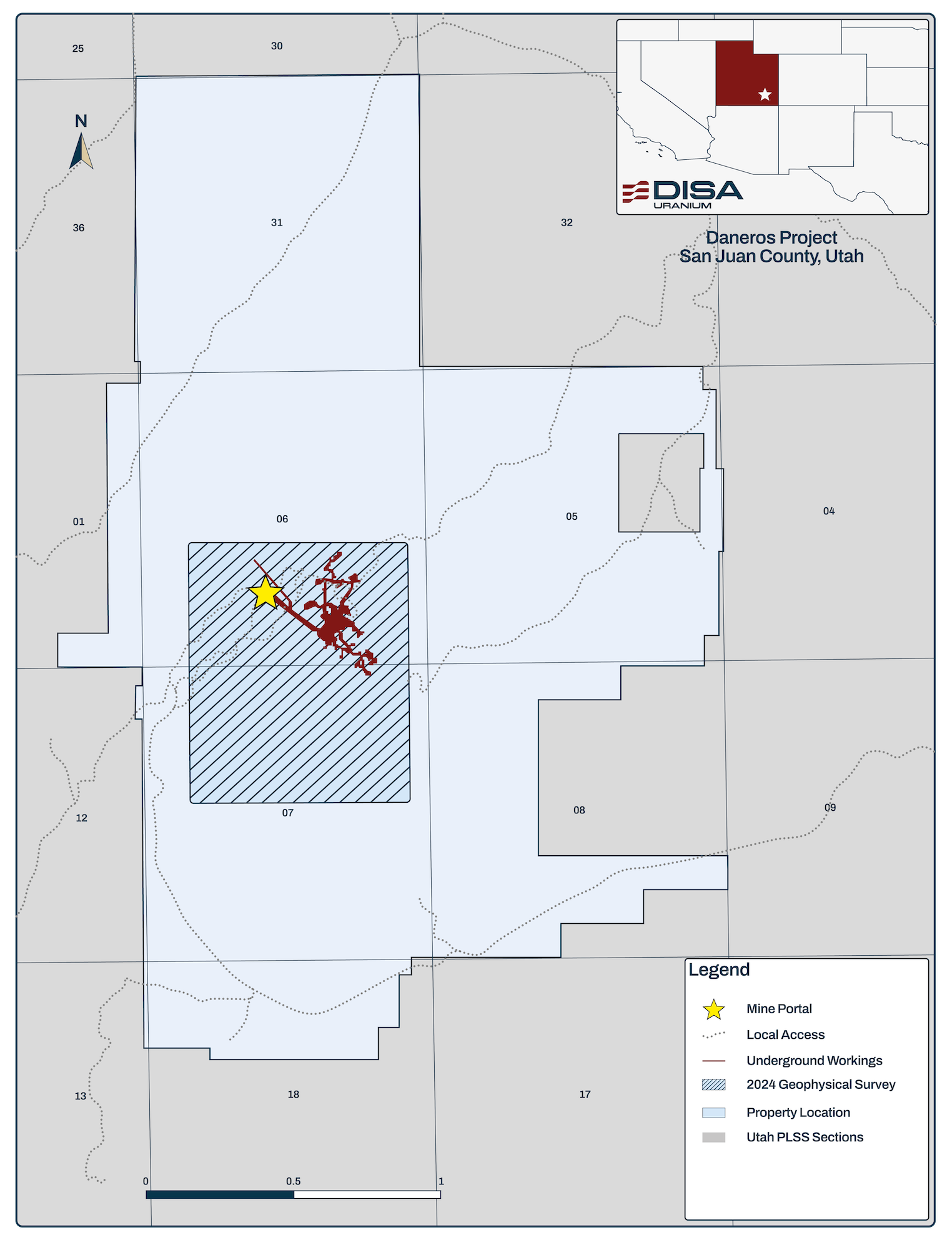
Daneros is a fully developed and permitted underground mine in the White Canyon district — one of Utah’s most important historical uranium-producing areas. Brought into production in 2009 and operated through 2012, the mine was placed on standby with its portal, underground workings, and permits intact. Uranium at Daneros sits at the base of the Chinle Formation in fluvial channel sandstones, with higher-grade mineralization concentrated in paleochannels more than 20 feet thick.
- Operated 2009–2012; approximately 628,000 pounds U₃O₈ produced from Daneros, plus approximately 314,000 pounds from the adjacent Cove (Lark), Bullseye, and Spook mines on claims now held with the property.
- 2023 confirmation drilling: five holes totaling 2,280 feet, every hole intersecting significant uranium mineralization in the targeted Shinarump host.
- Drilling continues to confirm the continuity, thickness, and grade of mineralization, consistent with the White Canyon district.
- Additional resource potential indicated by historical resources at the Lark and Royal; 2024 seismic surveys and sedimentological mapping integrated to define new drill targets.
Historical Mineral Resource Estimate
Category
Tons (000s)
Grade (% U₃O₈)
Contained (000s lbs U₃O₈)
Indicated
20
0.36
142
Inferred
7
0.37
52
Notes: Mineral resources classified in accordance with CIM Definition Standards, estimated at a cut-off grade of 0.23% eU₃O₈ using a long-term uranium price of $55 per pound U₃O₈, a minimum thickness of 1 foot, and a bulk density of 0.07143 ton/ft³. Mineral resources are exclusive of mineral reserves and do not have demonstrated economic viability. Numbers may not add due to rounding. For additional information, refer to the Technical Report entitled “Updated Report on The Daneros Mine Project, San Juan County, Utah, U.S.A.” dated March 2018, prepared by Peters Geosciences. This resource is a historical estimate under National Instrument 43-101 – Standards of Disclosure for Mineral Projects (“NI 43-101”), and a qualified person has not done sufficient work to classify the historical estimate as current mineral resources. As a result, the historical estimate is not being treated as a current mineral resource.
Historical Production
URANIUM AND VANADIUM, ON THE URAVAN BELT.
RIM MINE
Location
Uravan Mineral Belt, approximately 15 miles northeast of Monticello, San Juan County, Utah
Deposit
Tabular sandstone-hosted uranium and vanadium
Stage
Past-producing underground mine on care and maintenance; restart with relatively little permitting or development
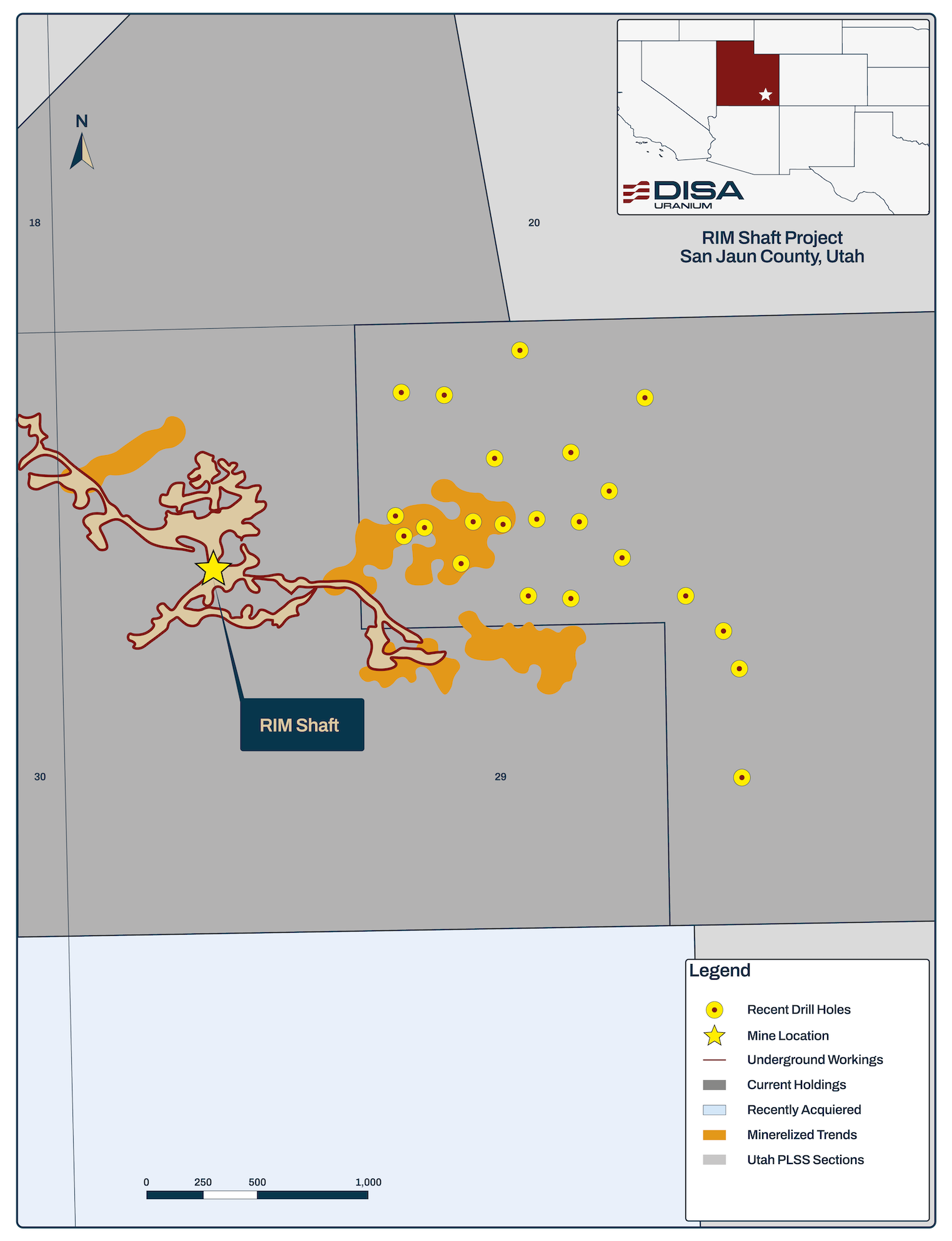
Rim has produced on a periodic basis since the mid-1960s, most recently under Denison Mines from 2008 until a low uranium price idled it in late 2010. Surface infrastructure, portals, declines, and underground workings remain in place, and the property has been held on care and maintenance so that it can be restarted quickly. The land package — 26 unpatented lode mineral claims, a private lease, and a Utah State mineral lease — totals about 1,100 acres.
- High vanadium-to-uranium ratio of 9.25:1.
- Portals, declines, underground workings, and surface infrastructure in place.
- 2023 drilling: 15 combined rotary and core holes totaling 11,395 feet, confirming historical grades and thicknesses and pointing to extensions of known mineralization onto recently acquired ground.
- 2024 orientation seismic surveys over known mineralization, integrated with sedimentological mapping and historical data to generate new drill targets.
THE CALLIHAM MINE, AND ROOM TO GROW.
SAGE PLAIN
Location
Slick Rock district, approximately 15 miles northeast of Monticello, San Juan County, Utah
Deposit
Tabular sandstone-hosted uranium and vanadium
Stage
Past-producing; underground workings intact, declines can be re-established for re-entry
Sage Plain comprises two fee mineral leases covering about 960 acres (Calliham and Crain) and a 640-acre Utah State lease. Its Calliham Mine was explored by Hecla Mining in the early 1970s, brought into production by Atlas Minerals in 1976, and operated again by Umetco Minerals in 1990–1991 during a spike in vanadium prices. Surface infrastructure has since been removed and permits have lapsed, but the underground workings remain relatively intact and the declines could be re-established for quick re-entry — making Sage Plain the earlier-stage restart in the portfolio, with a high vanadium-to-uranium ratio.
Historical Mineral Resource Estimate
Category
Tons (000s)
Grade (% U₃O₈)
Contained (000s lbs U₃O₈)
Grade (% V₂O₅)
Contained V₂O₅ (000s lbs)
Measured
240
0.16
772
1.32
6,349
Indicated
13
0.10
26
0.77
199
Inferred
10
0.13
25
0.94
188
Notes: Grades and tonnages shown as diluted amounts. Vanadium grades are based on assays where known, otherwise estimated at the average V₂O₅:U₃O₈ ratios for the individual properties used by previous operators based on core assay data and past production. Mineral resources classified in accordance with CIM Definition Standards. For additional information, refer to the Technical Report entitled “Updated Technical Report on Sage Plain Project (Including the Calliham Mine)” prepared by Douglas C. Peters, CPG of Peters Geosciences, dated March 18, 2015. This resource is a historical estimate under National Instrument 43-101 – Standards of Disclosure for Mineral Projects (“NI 43-101”), and a qualified person has not done sufficient work to classify the historical estimate as current mineral resources. As a result, the historical estimate is not being treated as a current mineral resource.
Historical Production — Calliham Mine
Operator
Tons (000s)
Grade (% U₃O₈)
Contained U₃O₈ (000s lbs)
Grade (% V₂O₅)
Contained V₂O₅ (000s lbs)
Atlas
209
0.15
605
0.90
3,773
Umetco
13
0.21
56
1.29
343
Total
221
0.15
661
0.93
4,116